


CALIFORNIA'S CENTRAL COAST (Part 2 of 2)
From Big Sur to the Santa Cruz Boardwalk; there's nothing quite like a road trip on CA State Route 1.

It was here in Big Sur that I first learned to say “amen.” - Henry Miller
When you’re done drinking wine, watching elephant seals, being an aristocrat at Heart Castle, and strolling along Moonstone Beach, it’s time to get your ass back in the car — there’s a lot of road to cover. As we head northbound up California’s Central Coast, between San Simeon and the Carmel Highlands, BIG SUR is calling.1
There are a lot of firsts in our lives. The truly great firsts are easy to recognize; when you’ve never experienced something before — a first time hearing your soon to be favorite song, a first time eating your soon to be favorite food, a first kiss, a first love, a first brush with death — you know exactly when you are encountering it for the first time, because it completely takes over your entire mind, body, and soul. It instantly grabs a hold of you. That very first time, almost immediately, leaves you wanting to have that mesmerizing, out-of-body experience all over again, as soon as possible.
The first time you see Big Sur — windows rolled down on a sunny California day — is one of those unforgettable, out-of-body experiences.
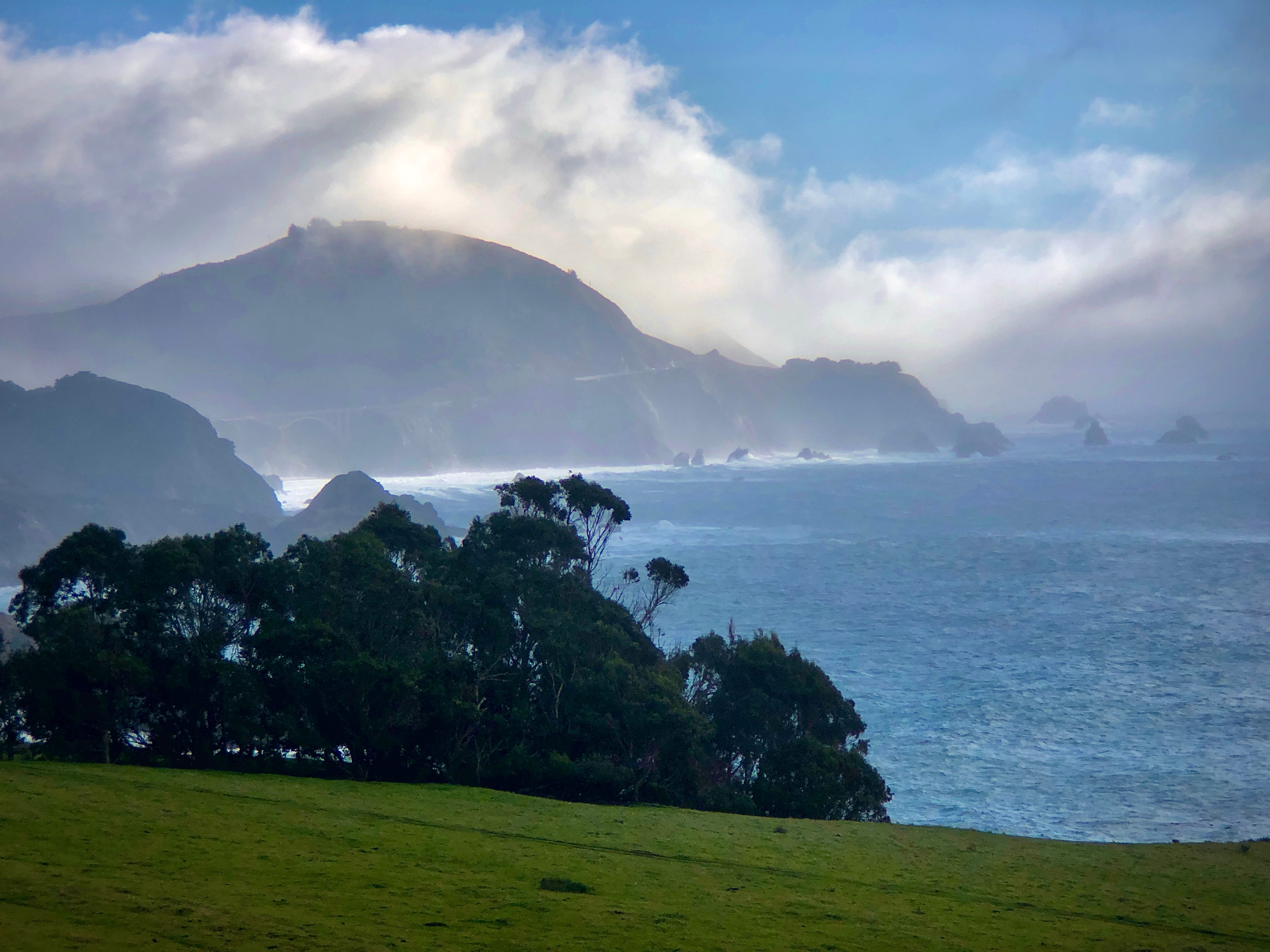
Big Sur is a rugged and mountainous section of California’s Central Coast, between Carmel Highlands and San Simeon, where the Santa Lucia Mountains rise abruptly from the Pacific Ocean.
Frequently praised for its dramatic scenery, Big Sur has been called many things: the "longest and most scenic stretch of undeveloped coastline in the contiguous United States", a "national treasure that demands extraordinary procedures to protect it from development", and "one of the most beautiful coastlines anywhere in the world; an isolated stretch of road, mythic in reputation".
With breathtakingly dramatic views, redwood forests, hiking trails, and state beaches, Big Sur has become one of the most popular tourist destinations in the United States. It is said that 4.5 to 7 million people visit Big Sur, annually, making it comparable to the annual number of tourists that visit Yosemite National Park, but with far less parking, roads, attractions, and infrastructure.2
I’m not going to lie to you, Big Sur can be a shit-show. There is only one, two-lane road on this route; the cars, busses, RVs, and motorcycles, as you can imagine, pile up quickly. The term “rubbernecking” is the first thing to pop into my mind, when driving down this breathtaking, cliffside oasis, and there’s nothing you can do about it.
Bixby Creek Bridge, Castle Rock Viewpoint, and Rocky Creek Bridge are some of the legendary rubbernecking points along this scenic route. As much as this is a road trip, this is also a “park the car on the side of the road, get out, and walk” trip. You will need to get out of the car, at some point, because the traffic will be bad and it’s always a better idea to get out and go on a walkabout.
Typically, I’d offer up some great food options, along the way, but I’m not going to do that with Big Sur; at the end of the day, this trip is about enjoying Mother Nature in all her glory. This trip is all about being outside and enjoying the view. Okay, well…fine…if you insist…I’ll give you ONE spot to check out, along the way. At the start of your journey, as you’re entering into the “official” Big Sur drive, you will come across a wonderful road-side eatery, Big Sur Bakery. This place looks like a mountain-side cabana, just off the main road, with a large outdoor patio surrounded by beautiful gardens. As you can imagine, they have some delicious baked goods; however, they also serve some wonderful wood-fired pizza, salads and sandwiches, and other, classic breakfast fare.
Once you’re back on the road, you will see a large number of other, fellow travelers with selfie sticks, not paying attention to oncoming traffic, probably not paying attention to their snot-nosed kids running all over the road, and there’s nothing you can do about it. People come from all over the world to see this rugged landscape. I know I keep reminding you about how busy it’s going to be, but you need to be prepared for the onslaught of densely packed tourists.
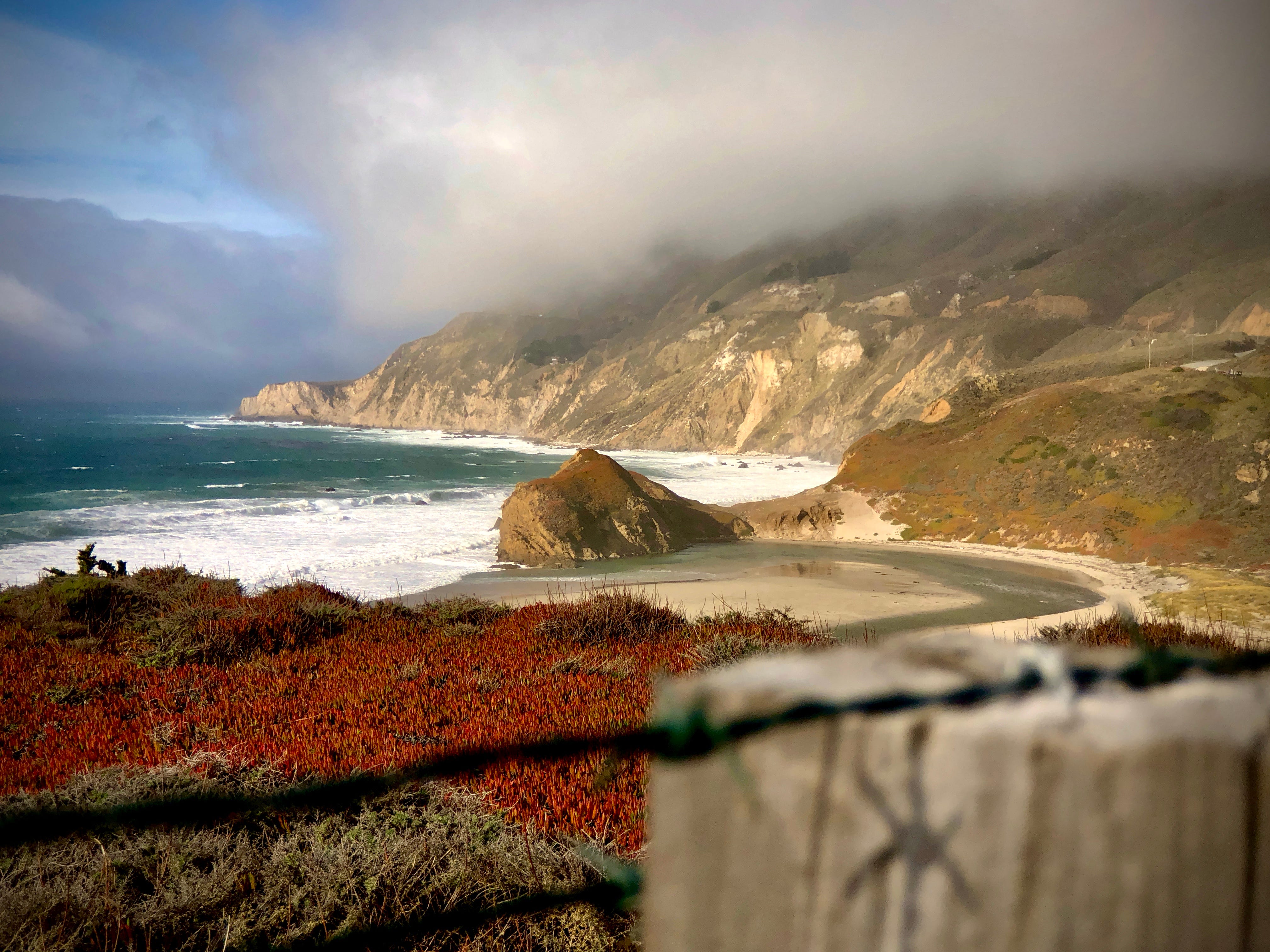
But, you know…since you’re asking me so nicely…there is a secret to seeing Big Sur. The best time to see this place, from my personal experience, is on New Years Day. Think about it…everyone is hungover from NYE, the night before, so the LAST thing they want to do is drive a few hours away, on a narrow, winding road, with very few places to stop at if you need a break. In fact, the last time I took the Big Sur Drive was on New Year’s Day; there were moments that I truly thought we had the place to ourselves. We left Los Angeles, right at 7am, and by the time we got to Big Sur, the clouds had just started to burn off and the sun was ready to grace us with her presence for the rest of the afternoon. We pulled off the road, just past Castle Rock Viewpoint, and started walking around the coastline. The last photo, above, shows the POV we had that early afternoon. Do you see the clouds rolling away? Do you see the sun coming out? Do you see a single person anywhere in that photo? I’m telling you: New Year’s Day, that’s the play.
There are some campgrounds, hiking trails, and even a golf course, inland, hidden up in the mountains, but we decided to spend the better part of the afternoon walking around the coastline, taking it all in, enjoying every moment. Besides, you have to drive all the way up to Carmel-by-the-Sea, down and back around to Carmel Valley, or further, just to get to some of these places. My advice: when in Big Sur, stay near the water.
After you spend the day in Big Sur, it’s time to head 30-45 minutes north to Carmel, a city that’s “split” into two. While Big Sur is known for its rugged landscapes, remote life, and quiet, pristine beaches and mountains, Carmel is known for its lavish homes, expensive shops, high-end restaurants, art galleries, and performing arts spaces. You go to Big Sur to wind down and relax; you go to Carmel to spend money and have a good time.
Outside of Big Sur, the main attraction of Monterey County is Carmel-by-the-Sea, commonly known as Carmel. Carmel-by-the-Sea might be the epitome of a world-class California coastal town. The town sits atop the Monterey Peninsula, overlooking the Carmel Bay, and is one of the most scenic places to visit in all of California. If Santa Monica, CA and Santa Barbara, CA had a baby, it would look a lot like Carmel, but more expensive, with far less people, and much cleaner. It’s consistently ranked as one of the most expensive and most desirable places to live in all of California. Carmel is the way it is because of two things: tourism and retirement.
In 2022, the U.S. Census reported that Carmel-by-the-Sea had a population of 3,240 residents, most of whom already own their homes; the median property value was $1.76 million; over 1/3 of all jobs are in the food, beverage, or retail service industry; 100% of the total population had health insurance; the median age is 65 years old. Needless to say, if you’re a resident of Carmel, you’re probably old and you’re probably well off.3
Aside from its beauty, downtown Carmel is known for its boutique shops, restaurants, art galleries, and wine tasting rooms. As Visit Carmel-by-the-Sea states:
Chicago has the Miracle Mile, Paris the Rue Saint Honoré, and Rome the Via del Corso. Beverly Hills boasts Rodeo Drive and New Yorkers love 5th Avenue. And Carmel-by-the-Sea has Ocean Avenue.
Now, I’m not quite sure Ocean Avenue is comparable to any of those ridiculously famous places, but you get the idea. Anywhere east of Juniper Street—between 5th Avenue and 8th Avenue, with Ocean Avenue smack dab in the middle—will be crawling with like-minded travelers flocking to the hundreds of boutique shops and restaurants downtown Carmel has to offer. Before, during, or after shopping you can enjoy any of the 20 different wine tasting rooms downtown Carmel has to offer. Although this area isn’t as popular as Napa or Sonoma (the bigger wine destinations in California) Monterey is home to almost 350 vineyards, all producing quality varietals; Chardonnay and Pinot Noir being the top two in the area.
A trip to Carmel wouldn’t be complete without a visit to Mission San Carlos Borromeo de Carmelo—also known as The Carmel Mission. As stated in Part 1 of this article, the Spanish established 21 missions (religious outposts) in California, all of which played a key role in settlement and growth of the state. The Missions provide a great, inexpensive option to learn about the history and culture of Central California. In addition to its activity as a place of worship, Mission Carmel also hosts concerts, art exhibits, lectures, and numerous other community events.4
After the Mission, head west until you hit Carmel Beach. There are two ways to see this beach: take a stroll on the dog-friendly beach, or stay in your car and drive up and down Scenic Road (a fitting name). To the south, you can find “The Cabin on the Rocks”— a house, designed by Frank Lloyd Wright, that looks as though it’s a ship cutting through the waves. To the north, you can find Pebble Beach — one of the prestigious golf courses that hosts the U.S. Open.
If you’re like me, and you want to avoid the tourists, then I recommend heading 15 minutes inland to Carmel Valley. Technically, Carmel Valley is anywhere east of CA State Route 1, along the Carmel River, but most people would find Carmel Valley Village to be its main hub. Carmel Valley is tiny, compared to Carmel-by-the-Sea, and its downtown consists of about 5 blocks; however, there are more than a dozen wineries and hotels in this small part of town. I prefer to stay in Carmel Valley, over Carmel-by-the-Sea, because it has more of a country feel with far less tourists. Additionally, there’s something nice about waking up early in the morning, getting a cup of joe, and strolling the misty streets of Carmel Valley Road as the morning dew waits to get burnt off by the rising sun.
THE SALINAS VALLEY is a long narrow swale between two ranges of mountains, and the Salinas River winds and twists up the center until it falls at last into Monterey Bay. Not everyone has the good fortune to be born in Salinas. - John Steinbeck
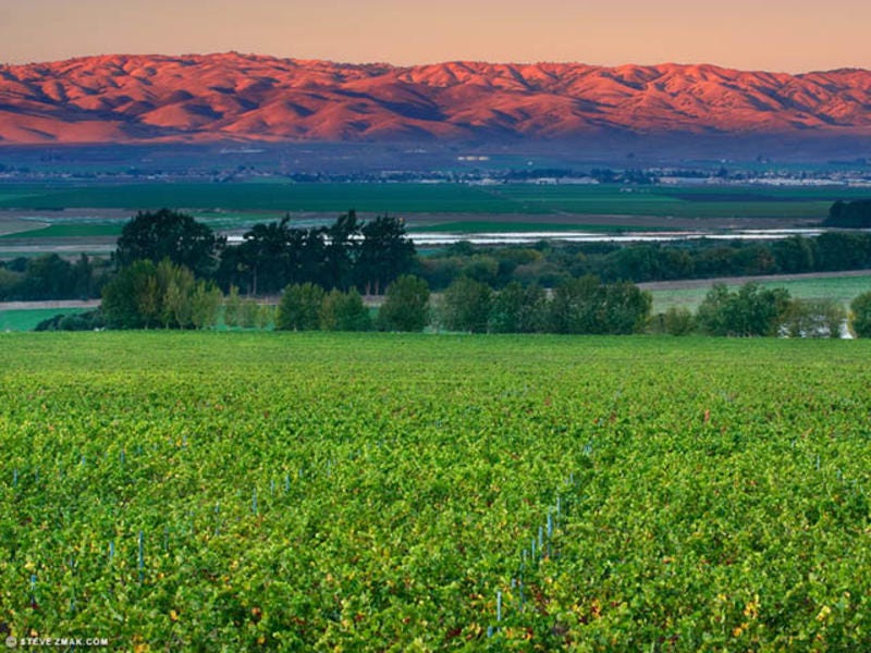
Since we’re on a road trip, let’s get back in the car and—dare I say—skip the rest of Monterey. Instead, let’s take a drive back in time through Salinas Valley, the “Salad Bowl of the World”; Steinbeck Country. Salinas Valley grows half of the nation’s lettuce, a third of its spinach, broccoli, peppers, and numerous other crops; the agriculture industry is the heartbeat of this part of the country. Salinas is also emerging as the AgTech capital of the nation and a global hub for agricultural technology.
Salinas is similar to Detroit in the sense that it used to be an affluent, booming city. In 1924, Salinas has the highest per capita income of any city in the United States. During the growing seasons of the Great Depression, the volume of telephone and telegraph transmissions originating in Salinas was greater than that of San Francisco. In 1920, thanks to the automotice industry boom, Detroit became the fourth largest city in the United States. Thanks to industrial pioneers, like Henry Ford, the automotive industry established Detroit's status in the early 20th century as the world's automotive capital. In 1950, the city held about one-third of the state's population. Over the next 60 years, the city's population declined to less than 10 percent of the state's population. Both Salinas and Detroit now get overlooked, when talking about visiting either of the areas, because practices like offshoring and outsourcing have completely changed the landscape of the once booming industries both cities prospered from. Although Salinas is making a comeback, thanks to that booming AgTech industry, residents are still locking down to other closer, bigger, more prosperous cities like San Francisco, San Jose, Santa Cruz, Modesto, and Fresno. Nonetheless, Salinas stands as an example of a city righting to reinvent itself through an ever changing landscape of the fast moving progression of the United States and its recycling of booming industries.
We end our California Central Coast roadtrip in the hippie-surfer-college town of Santa Cruz. Santa Cruz, with its laidback hippie vibes, beach boardwalk, and relaxing scenery, is the perfect respite after a long journey on the road. The University of California Santa Cruz adds a layer of uniqueness to this town, because, like most thriving college towns, the students keep a great dichotomy between sleepy and party vibes.
Santa Cruz is the actual midpoint of California, roughly 450 miles to both the northern and southern borders. Contrary to popular belief, San Francisco—and the rest of the Bay Area, at that—is not REALLY in or part of Northern California. It is something I will never understand, but, for whatever reason, anything north of Napa and Sonoma is almost entirely dismissed or forgotten about. I digress.
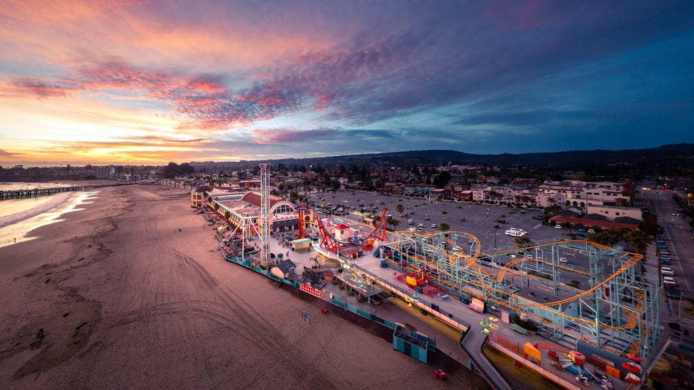
The Santa Cruz Beach Boardwalk is an oceanfront amusement park; the oldest surviving amusement park in the state of California. The boardwalk extends along the Monterey Bay, just east of the Santa Cruz wharf, and offers amusement rides, roller coasters, arcade games, laser tag, mini-golf, and snack booths. If you’ve ever been to the Santa Monica Pier—where you’ve been let down by the attractions, homeless people, and lack of interesting things to do—don’t sweat it, because this the better version of that. If, at this point, you’re tired of hanging out on the beach, head inland to Henry Cowell Redwoods State Park. There are over 15 miles of hiking trails, some of which lead to small, isolated sandy beaches on the San Lorenzo River, and others with overlook views of the Santa Cruz Mountains, with peeks at Monterey Bay. However, the main attraction is the Redwood Grove — the sky-scraping trees are old-growth "virgin" redwoods, the oldest trees of which are approximately 1,400–1,800 years old and grow to approximately 300 feet tall and over 16 feet in diameter. You haven’t experienced the beauty of Mother Nature without seeing one of California’s prestigious redwoods.
An afterthought:
Although my time living in California has come to an end, it’s researching articles, like this one, that make me realize how special of a time it was for me to be in California, for all of those years. California, like plenty of other places in this world, has its problems; insane price hikes, unaffordable housing, extreme homelessness, and a wiping out of the middle class has left California in the middle of a major change, in my opinion. Although, after living there for almost half of my life, I do think it was, is, and can be one of the most beautiful places in the world. I’ve always said: the best thing about Los Angeles is the ability it has as being a major jumping-off point to some of the most spectacular places in the world. If you head two hours south, you’re in San Diego. If you head two hours inland, you’re in Palm Springs or Joshua Tree. If you head two hours north, you’re in Santa Barbara County; the start of the Central Coast tour.
I may not be a Californian anymore, but the wonderful memories I have, from these amazing adventures, will always burn bright in my soul. They will be a fuel to the fire that drives my curiosity to see and experience the most mesmerizing things this big and beautiful world has to offer.
Until next time…keep burning bright.
Always make sure to check CALTRANS, because as of now (June 2024) CA State Route 1 is closed from Limeklin State Park to the Dolan Creek Bridge. Do not bother going if these roads are closed. Big Sur isn’t going anywhere, so wait until it’s all fully open.
I could go down a serious rabbit hole reading statistical information from the U.S. Census